| What to do with Benelux.: 12/16/2011 21:50:34 |

Moros 
Level 50
Report
|
No, I'm still working on making all those territories... Because of school I haven't had much time last 2 weeks, but in one week I'll have vacation for two weeks, I'm trying to keep my promise of 1st of January, but please don't be mad if it'll come out a little later :)
For so far I'm done with about 260 territories, but a lot of them are coastal territories, so it takes more time to make those than normal ones.
I can show another pic, this is how I make airports and ports visible:

Ignore the weird background colors, and the one who first guess which part I'm showing gets a cookie :)
|
| What to do with Benelux.: 12/16/2011 21:51:07 |
Moros
Level 50
Report
|
guessES (typo)
|
| What to do with Benelux.: 12/16/2011 23:45:14 |
RvW
Level 54
Report
|
What weird background colour? It's orange! :)
Looks very nice and clean (quite a difference with "Europe Realistic" for instance). Is it intentional for the airport to be "hollow" though? Or is that going to be invisible once you remove the background (standard WL background is black anyway...)? I think it's a great idea to mark the "wormhole" territories like this, it will be much clearer than drawing connection lines all over the place.
Okay, my real reason to post: I wanna cookie! :) So let's see. That thick line cannot possible be a country border (there are no three-country points within the Benelux), so it must be "just" a province border or something (I'm guessing it's a bonus border in-game, right?).
If West is up (like you said you were planning) than I've got no idea what part of the Benelux this could possibly be; the only part of the Benelux with a significant body of water to the East of it is North Holland, but it can't be Enkhuizen (there's no airport around there which I know of) and it can't be Amsterdam (each territory is a municipality, so if it was Amsterdam, it should be much bigger than the surrounding territories).
With North being up, it could be the IJsselmeer coast of Friesland, but all other details don't match up...
East can't be up either; the North Sea coast is a lot smoother than that.
I'm guessing that part below the harbour isn't sea at all, it's territories which you haven't drawn yet; that harbour isn't on the sea, it's on one of the major rivers. Without knowing which cardinal direction corresponds with "up", and without a clue which territories are still missing (and what parts really are sea), I have no idea how to put a location on this part of the map... :(
(Let's visit some ad-servers, they give out cookies for free! ;) )
|
| What to do with Benelux.: 12/17/2011 00:07:13 |
RvW
Level 54
Report
|
ps. Don't forget about Matma Rex's connection editor: http://warlight.net/Forum/Thread.aspx?ThreadID=2452 this might be a nice test-run for it.
|
| What to do with Benelux.: 12/17/2011 11:06:36 |
Moros
Level 50
Report
|
Okay, the first hint for the map picture is: the shown port is indeed a river port, and west is up.
And yes, I'm making the airport signs hollow, but I'll make a non-territory object below it to have a standard color. Any ideas for the color?
@Ognian
For most complicated parts, e.g. the port of Rotterdam, the TINY communes in Brussels, the map I'm using as a base isn't detailed enough, so I get a new smaller map from the internet, make it semi-transparent, re-scale and turn and twist it so it fits with the base borders and than draw over that one. I'll do the same with Baarle-Nassau.
@RvW's second post
I would do that, but I have no idea how the API editor works :(
All I get when I click the link on the wiki I get this:
This XML file does not appear to have any style information associated with it. The document tree is shown below.
-------
<root>
<termsOfUse>
Please use this API responsibly, as it can consume significant amounts of server resources if called excessively.
</termsOfUse>
<error>Root element is missing.</error>
</root>
And no buttons or similar things I can click to enter the map ID. Any beginners-tutorial is very welcome!
|
| What to do with Benelux.: 12/17/2011 13:02:00 |

Domenico
Level 16
Report
|
Right, as for the map fragment, I found a border shape that looked like the thick lines in your picture: the border between the Luxembourg regions of Wiltz, Redange, and Diekrich, but I'm not sure if there's a harbour or an airport there.
I am sure it can't be Rotterdam, the municipality of Rotterdam is far bigger than its surroundings.
So yeah, I'm going to guess it's a part of Luxembourg.
And again, it looks great. Looking forward to this epic map... :)
|
| What to do with Benelux.: 12/17/2011 14:25:19 |
Moros
Level 50
Report
|
|
| What to do with Benelux.: 12/17/2011 14:31:46 |
Moros
Level 50
Report
|
oh, btw, Ognian inspired me to do the Baarle's, but as you can see it didn't turn out as pretty as I wanted, on the right you see the Biesbosch, and the blob on the left is Baarle-Hertog/Nassau:

|
| What to do with Benelux.: 12/17/2011 15:00:23 |

Matma Rex
Level 12
Report
|
@centerpoint editor
Have you tried running it? Apart from the scary white-text-on-black-background console window, it's pretty easy to use. Just copy the exe file to the same folder as your SVG file and run it.
Note that the map has to uploaded in development mode already, and that the territory ids need to be set. (I've made a tool for that, too: http://dl.dropbox.com/u/10983006/tmp/warlight_territories.exe, but it only works with Inkscape-made maps.)
|
| What to do with Benelux.: 12/19/2011 14:23:08 |
Domenico
Level 16
Report
|
Woohoo! *takes the cookie* OM NOM NOM!
Keep up the good work, Moros.
|
| What to do with Benelux.: 12/26/2011 12:21:05 |
Moros
Level 50
Report
|
Okay, I need advise on the bonuses. There are two possibilities:
1. I make every province a bonus. In that case we'll have 12+10+3=25 bonuses, but at 1100 territories it'll make an average of 1100/25=44 territories per bonus, what I consider very large.
2. I make the COROP-areas, *arrondissementen* and cantons a bonus too, that'll make 43+40+12=95 bonuses, or 1100/95=11,5 territories per bonus. That's still a bit large, but smaller than first. But, in that case, because I want the countries, and provinces a bonus too, and I'm also grouping Flanders and Walloon together, and I'm thinking of dividing the Netherlands in two as well, than we have 4 layers of bonuses.
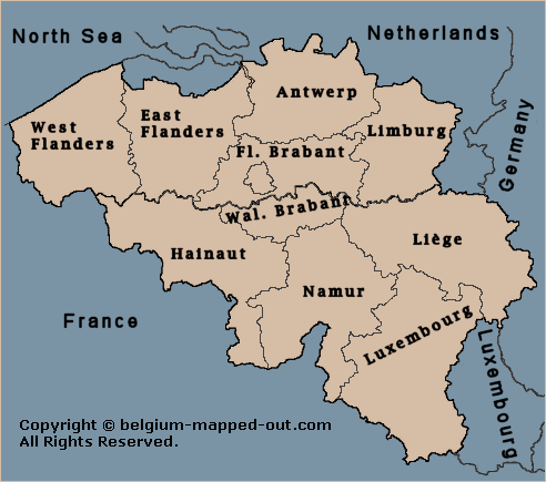
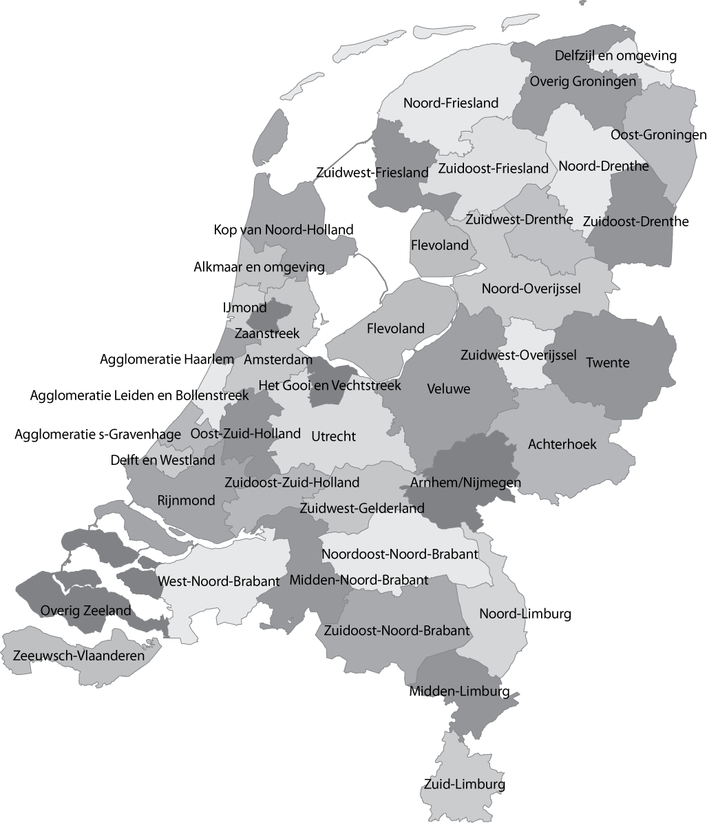
To give a clear idea, here are the [provinces of the Netherlands]( http://lajhsslab.com/europe/netherlands/images/nl_map_provinces.gif) and [Belgium]( http://www.belgium-mapped-out.com/image-files/belgiumprovinces.png), and the [districts of Luxembourg]( http://upload.wikimedia.org/wikipedia/commons/thumb/1/1d/Luxemburg_districts.svg/220px-Luxemburg_districts.svg.png)
And here are the [COROP-areas of the Netherlands]( http://upload.wikimedia.org/wikipedia/commons/c/ce/Coropgebieden_plain.png), [the arrondissementen of Belgium]( http://download.tuxx.nl/bouwvakantie_belgie_2010/belgie.jpg), and [the cantons of Luxembourg]( http://www.luxembourg.public.lu/pictures/photos/cartes/politique.jpg).
Tell me what you'd prefer please.
|
| What to do with Benelux.: 12/26/2011 17:22:53 |
Domenico
Level 16
Report
|
The second idea sounds like the best idea. So the four layers of bonuses are:
1. The Corop Areas (NL), arrondissements (B), and cantons (L).
2. The provinces (NL & B), and districts (L).
3. The regions of the Netherlands and Belgium (and Luxembourg).
4. The three countries.
If you split up the Netherlands, I wouldn't cut it in half, but in four pieces, the way NMI did in his small map.
|
| What to do with Benelux.: 12/26/2011 17:34:24 |
Moros
Level 50
Report
|
But if I cut it into four pieces, it'll give way more armies for 400 territories than Belgium, which I split up in Flanders and Walloon. I think I'm splitting it up in Randstad (Noord-Holland, Zuid-Holland, Utrecht and Flevoland, together 162 territories) and the rest (258), that's pretty much equally divided, and realistic. But how should I name the Netherlands outside the Randstad? I was thinking of *Achterland*, but maybe that's a bit degenerating.
|
| What to do with Benelux.: 12/26/2011 17:35:15 |
Moros
Level 50
Report
|
Oh, and I'm not splitting up Luxembourg, it's too small to be balanced if given even more armies.
|
| What to do with Benelux.: 12/26/2011 19:10:54 |
Domenico
Level 16
Report
|
Naturally. That's why I said regions of Netherlands and Belgium, and Luxembourg (by which I meant Luxembourg as a whole.)
I am not sure if the division I proposed is so imbalanced. As long as the value is not too high, it needn't be imbalanced.
I don't think there's a name for the non-Randstad Netherlands, and *Achterland* is indeed a bad idea. Sounds too much like *achterlijk*. ;)
Also, the Randstad does not really include all the parts of the provinces you mentioned.
I'd say the Randstad stops beyond Lelystad, Alkmaar, and Zeist. Urk, for example, is definitely not a Randstad city.
See, you can't really evade a little imbalance here and there. Look at The Netherlands Map alone, even though I've substantially weakened Flevoland, it's still probably the most favourable starting location for a one-territory start with a normal income, Dronten more specifically. Other good locations are Medemblik and Haarlemmerliede & Spaarwoude.
Anyhow, balance is a utopia when real maps are concerned. But whatever you decide, keep up the good work. I'm looking forward to the map.
|
| What to do with Benelux.: 12/26/2011 19:21:43 |
Moros
Level 50
Report
|
Do you know any good divisions?
|
| What to do with Benelux.: 12/26/2011 21:16:47 |
Domenico
Level 16
Report
|
Well, it's a hard nut to crack, but let me see. Let's assume that the Regions will be collections of equal amounts of provinces. That means you can divide 12 provinces by 2, 3, 4, or 6.
That means the first possibility is dividing our country into two groups of six provinces.
Because Belgium has been divided north-west, it makes sense to divide the Netherlands west-east:
1. Noord-Holland, Zuid-Holland, Utrecht, Flevoland, Friesland, Zeeland.
2. Drenthe, Overijssel, Gelderland, Limburg, Noord-Brabant, Groningen.
The names would then of course be West- and Oost-Nederland.
Then three groups of four. I couldn't find a mathematically sound division, but here's the best I could do:
1. Noord-Holland, Utrecht, Flevoland, Friesland.
2. Zuid-Holland, Zeeland, Noord-Brabant, Limburg.
3. Friesland, Groningen, Drenthe, Gelderland.
The second bonus would have about 70 more territories than the rest. The names might be IJsselmeer, Beneden de Rivieren, and Het Noordoosten (don't know any better name.)
Next, four trios. Numberwise the division NMI did and I proposed is a disaster. In fact, because the northeast bonuses are worth pennies, making four equal trios impossible, so I solved that this way:
1. Noord-Holland, Zuid-Holland.
2. Flevoland, Gelderland, Utrecht.
3. Zeeland, Noord-Brabant, Limburg.
4. Friesland, Groningen, Drenthe, Overijssel.
Then the names will be Holland, Midden-Nederland, Zuid-Nederland, and Noord-Nederland.
I also tried to make six duos, but I appreciate that if you think four trios already cause an imbalance, it's silly to make six twosomes, plus I couldn't make the numbers fit anymore without making combinations like Gelderland-Limburg, which just looks funny...
|
| What to do with Benelux.: 12/26/2011 23:17:31 |
Moros
Level 50
Report
|
Well, I have to split the Netherlands in two, because I've split up Belgium in two too. And I want the border to be somewhat realistic, because the Belgian division is the two language zones.
|
Post a reply to this thread
Before posting, please proofread to ensure your post uses proper grammar and is free of spelling mistakes or typos.
|
|

