| New Map: Large Earth: 12/8/2011 11:00:32 |
emoose 
Level 7
Report
|
I'm basically a total newb when it comes to WL's maps as I mostly play the Earth maps, but it bothers me a little that many of the world's smaller countries and islands are left out of these maps, and I also feel many more overseas territory links should exist. (Even to me that doesn't really justify creating a new map, so feel free to call me crazy, but it's the only reasoning I can come up with as to why I'm motivated to do this). So, I've set myself the goal of learning to use InkScape, and making an Earth map that is as geographically and politically accurate as possible, without becoming overly difficult to play.
I found a great collection of maps [**here**]( http://www.lib.utexas.edu/maps/world.html) to use as image templates, but as I couldn't figure out how to download the 2011 Political map's PDF format (let alone in a way that I can put it into InkScape), I went with the 2008 Political map (jpeg format which I easily downloaded, cut down, and inserted).
While I put the draft of the map together in my spare time, there are a few things on which I would like to have input from veteran players:
- My plan was to have the only bonuses be continental ones, but this has some concerns for me. From my understanding, there are 5 geographical continents: **North America** (including Central America and Greenland), **South America**, **Antarctica**, **Oceania** (including Australia, New Guinea, and several small islands which I'm not sure will be on the map yet), and lastly **Afro-Eurasia**. The first 4 aren't problematic, but as most of the world's land mass as well as a very high number of countries are within Europe, Asia and Africa, the game would be decided by the time anyone completes the **Afro-Eurasia** bonus.
- A more realistic system of bonuses is to base them on real-life military powers. The first problem this presents is how many armies each military power should provide, as well as which countries that don't have an organized military should provide a bonus and how much of a bonus those countries should provide (think guerilla warfare and militia type of things). Second, I feel that in the cases of large countries (Canada, U.S., China, Russia), you conquer individual major military bases within that country, and with them you gain whatever surrounding area would normally be under that base's protection. Although I like this bonus system better, it would require a *tremendous* amount of research and user input.
- Ideally I would like to include any territory that is clearly represented on the map I'm using as an image template. However, this will very likely end up with territories that are too small to click, or see the occupying armies. I want to maintain the original shapes as much as possible, and to do so I planned to have "army bubbles" that are linked to those territories, but are visually separate. The issue this creates is that the army arrows will (I think) travel to and from the army bubbles rather than the real territories, which may get confusing or create poor playing aesthetics.
---
Any input on those topics or general input you have on the map is appreciated. I may also add additional questions as I think about the map more. At this stage of the map design however,
***please ONLY present your own input, do not debate the input of other players***.
I have a very long way to go with just the basic draft of the map, and if I have to read through pages of the same people going back and forth over a single subject, I will lose motivation to complete the draft. When the map is closer to completion, I will hopefully be able to present more focused questions which can then be discussed more freely in order to perfect the map.
|
| New Map: Large Earth: 12/8/2011 11:26:44 |

Guiguzi
Level 58
Report
|
I like your basic premise.
About your ideas:
- Continental bonuses: not sure if that'd work.
- Bonuses based on real-life military capabilities: hard to do (warlight is a territory-based game, not a nation-based game involving diplomacy, ecomomics, etc.).
Suggestions:
- 1 country 1 bonus? It's not realistic, but it might get at what your basic premise states: to do this, simply include all countries in the world (192+)
- Bonuses: for larger countries, more regions needed for the bonus (divide larger countries into 3-5 regions but make the bonus based on the country only?); maps with most bonuses between 1 and 5 and a few bonuses of 6-8 are the best I think. Making all bonuses worth the # of territories minus 1 would be more balanced too.
- Connections & sea lanes: make all bordering countries connect to each other; maybe make major sea lanes as bonuses too and allow them to connect to adjacent lands.
|
| New Map: Large Earth: 12/8/2011 13:50:27 |

Richard Sharpe
Level 59
Report
|
"The issue this creates is that the army arrows will (I think) travel to and from the army bubbles rather than the real territories,"
This is correct, and to my knowledge, there is no way around that.
I would make a recommendation if you aren't too deep into your work. Use the following map:
http://en.wikipedia.org/wiki/File:CIA_WorldFactBook-Political_world.svg
If you right click and 'Save Link as...' it gives it as an SVG. Therefore, the borders would already have been created for you. If you don't use that particular map, I do recommend using the link trick to save one you do like though.
|
| New Map: Large Earth: 12/8/2011 13:55:40 |
Richard Sharpe
Level 59
Report
|
Though on second thought you may want to find another map since that one (20MB) caused Inkscape to be slow and eventually crash for me.
|
| New Map: Large Earth: 12/8/2011 14:47:15 |
RvW
Level 54
Report
|
A possible solution to some countries being tiny, some being huge is to enlarge some parts of the map; Europe, Middle America and South-East Asia come to mind. Take a look at Moros' "Canada Big" map for a WL example of the basic idea. The whole world could look something like [this]( http://a.stortcle.com/games/images/453_newworld_sudan.png). Note that it should be easy to first create the original size, then copy and enlarge it (that's far less work than drawing it all over again). The [Wiki]( http://wiki.warlight.net/index.php/Inkscape_tips#Unioning) explains how to combine both parts into a single territory.
Lines for attacking / transferring are indeed always drawn between centre points. You can put the centre points in the part large enough to click (and large enough to hold a number of armies) and the original map will still show the correct colour. This also makes it easier to see which enlarged territories connect to which "normal" territories.
The thing about bonuses is that you need them to get a workable income. If all bonuses are 20+ territories, on a 5-army base income that'll take *at least* ten turns to complete (2 armies per territory, no other players interfering). That'd be pretty boring... Also, when playing with wastelands, the risk of at least one wasteland appearing in a large bonus is pretty big. Some thoughts:
- You can make a number of small bonuses, and a large one. People would first conquer the Americas and Oceania, than go for the other continents, and finally invade Europe. Whether or not that makes for a fun game I can't say (it doesn't sound too appealing to me though). That would mean it's suicide to start in Europe. And, people might simply ignore Europe altogether since "it's not worth the effort". That would be a pity.
- The number of bonuses effectively limits the number of players; even holding a 3-army bonus when your opponent holds none (with the default 5-army base income that's 5 vs. 8) will allow you to easily crush him after a few turns. So, you need at least two or three times as many (easily conquerable; "Europe" doesn't count) bonuses as you want to have players. So, five bonuses translates to at most two players. (Note: there's nothing wrong with two player games, but you can also play two player on a much bigger map. I think it would be a pity if your map was limited to two players *only*.)
- I've never heard of "Afroeuraisa". At least split of Africa (there shouldn't be a practical problem with that). I'd also split Europe and Asia, but well, there's Russia... A possible (rather dirty) solution would be to split Russia into "Russia" and "Siberia", but that would break your one-country-one-territory concept. Anyway, just an idea. (This becomes a moot point if you don't base tour bonuses on continents).
In case you still want to use that 2011 version: simply zoom in as far as possible, but have it still fit on your screen. Hit "PrtScrn" (print screen), start Paint and press Ctrl+V. Now you can easily crop and save as BMP, JPG, PNG, etc. (However, I'm pretty sure it's a vector image internally, you could try Googling for a PDF-to-SVG converter / extractor, or maybe PDF-to-EPS...?)
Your idea with conquering army bases sounds very interesting, but I think it would be better suited to a "US army bases" map (or maybe a "North-America army bases" map) than to do it for the whole world.
Best of luck with creating this map, I'm already looking forward to it!
|
| New Map: Large Earth: 12/8/2011 14:50:07 |
emoose
Level 7
Report
|
Funny you should say that, I just finished rebooting because it caused my computer to become almost completely unresponsive.
lol
|
| New Map: Large Earth: 12/8/2011 14:50:35 |
emoose
Level 7
Report
|
^ @ Richard
|
| New Map: Large Earth: 12/8/2011 15:00:20 |
emoose
Level 7
Report
|
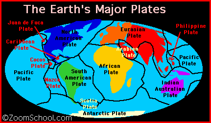
RvW: Fun fact - Africa, Europe and Asia all sit on the same continental plate (at least according to what I was reading on wikipedia), therefore Africa-Europe-Asia, shortened to Afro-Eurasia.
|
| New Map: Large Earth: 12/8/2011 15:29:16 |
Sewerrat
Level 3
Report
|
|
| New Map: Large Earth: 12/8/2011 16:48:18 |
emoose
Level 7
Report
|
At least now I know how clueless I am about geography (hopefully I at least have the subject right)...
Although starting with an SVG template that already has most things in place sounds nice, it seems a bit troublesome, and since drawing the territories and borders myself gives me the experience needed to properly edit the map anyways, I think I'll continue doing it that way.
One problem I'm noticing though, is that when zooming in/out, territory lines become jagged or slightly distorted in very weird ways. This doesn't really make sense to me, especially since it's *only* happening on the WL version - the original SVG on my computer has absolutely no problem of the sort. Anyone able to enlighten me? If it matters, I'm drawing mostly using the freehand tool, with a little use of the node editing to make small fixes.
Here's the public map link if you want to check the problem, or if you just want to follow my progress: [Large Earth]( http://warlight.net/SinglePlayer.aspx?PreviewMap=7440).
|
| New Map: Large Earth: 12/8/2011 16:53:56 |

Addy the Dog
Level 62
Report
|
instead of continental bonuses, bonuses could be based on either the territories or bonuses of the current earth maps. id also say that territories should all be around the same size in a decent map, so one country = one territory would not work. if you want to include small countries you definitely have to divide the larger ones up.
i think you should base divisions of countries on maps rather than things like individual military bases, unless you could find a map of them. otherwise, as well as all the research, you would have to draw it by hand, and the territories that would produce might turn out to be bizarre.
|
| New Map: Large Earth: 12/9/2011 02:13:42 |
RvW
Level 54
Report
|
|> One problem I'm noticing though, is that when zooming in/out, territory lines become jagged or slightly distorted in very weird ways. This doesn't really make sense to me, especially since it's only happening on the WL version - the original SVG on my computer has absolutely no problem of the sort. Anyone able to enlighten me? If it matters, I'm drawing mostly using the freehand tool, with a little use of the node editing to make small fixes.
There is a page on the [Wiki]( http://wiki.warlight.net/index.php/Inkscape_tips#Simplify) specifically about Inkscape tips. It mentions performance issues when borders contain "an excessively amount" of data. Your territories sure look very detailed (that's another way of calling them beautiful :) ), so you're going to run into that problem sooner or later; might as well warn you now.
The problem you describe also has to do with territory borders. I have no idea if the issues are even related, but they might; doesn't hurt to try, right?
|
| New Map: Large Earth: 12/9/2011 10:38:15 |
emoose
Level 7
Report
|
From the wiki:
|>Sometimes territories can contain way more data than they need. One example is after drawing territories with the pencil tool, if you view the vertices (F2) you'll see it has an excessive amount.
|>This is easy to fix simply by selecting Path -> Simplify (Ctrl+L). This reduces the number of vertices drastically, and in most cases, doesn't alter the appearance of the object at all:
|>Not only does this make the object easier to work with and increase the performance of Inkscape, it also reduces the size of your resulting WarLight map which makes it load faster and allows you to fit more objects into your map.
Believe it or not, the territories actually have far fewer vertices than you might expect, even at that level of detail (the map is also 3330x1741 px, so there's a lot of room for detail - not yet sure how it'll affect the file size). Also, the performance issues you mentioned are indicated by the wiki to be only in InkScape and like I said, this issue only appears when I upload the SVG to WL, not when I run it in InkScape.
---
|>The problem you describe also has to do with territory borders. I have no idea if the issues are even related, but they might; doesn't hurt to try, right?
I'm not really sure what you're trying to say here, care to elaborate?
|
| New Map: Large Earth: 12/9/2011 11:11:05 |
emoose
Level 7
Report
|
Edit: I had a file size error when I tried uploading the unsimplified line (44k nodes... lol) for the east coast of North America, which means I'll have to scale down and reduce detail.
|
| New Map: Large Earth: 12/12/2011 18:05:43 |
emoose
Level 7
Report
|
I started with a fresh map family to fix the scale more easily, so [**this**]( http://warlight.net/SinglePlayer.aspx?PreviewMap=7600) is the new link.
Richard gave me the idea (not sure if this is what he meant) of turning the oceans into territories. I've seen this on a map before and didn't like the way it looked at all (it's hard to visually distinguish that it's on water), but I'll give myself a chance to make it work more nicely. The three options I'm considering:
- Paint the ocean a static color and have an army dot in the middle
- Create full territories, but have a painted blue border on all coasts to distinguish them.
- Create groups of stripes, alternating between player color and painted blue, with a thin player-colored outline to show the borders.
Thoughts on this are much appreciated.
|
| New Map: Large Earth: 12/12/2011 22:35:54 |
RvW
Level 54
Report
|
Still beautiful, nice job! :)
For the ocean territories, how about doing one or two in each style (on an otherwise incomplete map, that's okay) and do a few test-games on it. This way you can more or less estimate how much work it will be (especially that last idea sounds like it might take a lot of work; estimate what you're getting yourself into) and how it works in a real game. That should make it a lot easier to decide which version to use for real. (If making such a testing map is a lot of work, remember, making the real map would take much, much more work...) Only real feedback I can give you at the moment is that all three sound promising and could probably work, but without seeing it "in action" it's difficult to decide.
|
| New Map: Large Earth: 12/13/2011 22:45:19 |

charfa
Level 13
Report
|
One problem with having oceans as territories on your map is that if you want to have a connection between ocean and every territory bordering with it, that would make a huge amount of connections for most of the oceans (except maybe Arctic Ocean). This would make oceans into major chokepoints. I guess you'd have to split oceans into smaller territories. Also, what about seas? You could turn Mediterranean, Red Sea, Baltic etc. into territories too, that would make it even more interesting to play.
But frankly, I believe having connections between major ports is better. Turning oceans/seas into territories makes map "flat" - every territory is connected to all territories around it - that's boring :]
As for the looks, all options sound good. (3) is interesting, I've never seen a territory made like this. It might look good, but it would be much more tedious to draw than the first two.
|
| New Map: Large Earth: 12/14/2011 00:34:09 |
Addy the Dog
Level 62
Report
|
i like the way the diplomacy map deals with its marine territories.
|
Post a reply to this thread
Before posting, please proofread to ensure your post uses proper grammar and is free of spelling mistakes or typos.
|
|
