<< Back to Map Development Forum   Search

Posts 1 - 20 of 75   1  2  3  4  Next >>   
Map of Croatian municipalities: 7/5/2013 13:06:58

CROivan
Level 46
Report
Lots of maps are aesthetically good looking and fun to play, but they have 'dull' shape - you can only move from east to west, north to south and opposite. But, few days ago I found this interesting map of Croatian municipalities and towns. This map looks fun because it also has many islands. I'm not asking for anyone to create this map (yet :D), but if it ever comes true I can help with naming. For now, I just want to ask what do you think about this map.

http://hr.wikipedia.org/wiki/Datoteka:Croatia_map_municipalities.svg
Map of Croatian municipalities: 7/5/2013 13:28:14


skunk940 
Level 60
Report
I don't get how this map is different from the others. Unless you mean that you can travel from one island to any other?
Map of Croatian municipalities: 7/5/2013 13:33:33


Min34 
Level 63
Report
I think that this map makes movement even less possible. It would not be a bad map, but the reason that you want to have more directions to move in, is not really a good one on this map.

North to south is harder and there are two south points now. from South to east is impossible, you'll have to go trough the north. It would not be a bad map, but movement is even less on this one :p
Map of Croatian municipalities: 7/5/2013 14:19:44

out of coins
Level 25
Report
war in croatia makes no sense if serbia isnt in it
Map of Croatian municipalities: 7/5/2013 17:49:59

CROivan
Level 46
Report
Min34: Yes, you're right. Dalmatia (south of Croatia) is very narrow and there's no movement in that part, therefore is suggest:
1.Adding connections between east Croatia (Slavonia) and Dalmatia
or
2. Have you ever played on map of France? On that map, Bruxelles, Luxembourg, Andorra and Monaco, thought not parts of France, added on that map and marked with a pentagon. So, why not add few Bosnian cities on that map to connect Slavonia and Dalmatia? Historically, Bosnia and Herzegovina was a part of Croatia, so it would still be logical if they would be added on that map. With them, also there could be added more cities that were in possesion of Croatia or where Croats are a significant minority (e.g. Burgenland in Austria, Molise in Italia, Crasovo in Romania, Kotor in Montenegro etc.)

anti-joker: Lololololo. I actually thought of a distribution mode where every player could be one of the national minority in Croatia, so that would be Serbs in Lika (between Dalmatia and central Croatia) and eastern Slavonia, Italians in Istria (the western most county of Croatia and the biggest peninsula in Croatia), Czechs in the city of Daruvar, Hungarians in Baranya and so on.
Map of Croatian municipalities: 7/8/2013 21:42:52


Moros 
Level 50
Report
I actually tried making this map a long time ago, but it was impossible to find the names.
Map of Croatian municipalities: 7/9/2013 13:18:55

CROivan
Level 46
Report
I can help you with naming if you want to make it
Map of Croatian municipalities: 7/10/2013 21:27:27


[NL] Emillio
Level 55
Report
So I understand you know the names of all the 429 Croatian municipalities from your head? Impressive!
Map of Croatian municipalities: 7/11/2013 09:37:01

CROivan
Level 46
Report
xD No, Emilio, but Croatian Wiki knows :)
Map of Croatian municipalities: 7/11/2013 10:12:08


Gnullbegg 
Level 49
Report
Really? There are 429 of them? Interesting...

Map of Croatian municipalities: 7/12/2013 08:48:18


Moros 
Level 50
Report
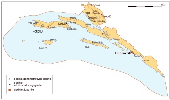
I checked the Croatian wiki, but all it did was give the names of them and their rough location. What I need is a map of Croatia with the municipalities named.
Map of Croatian municipalities: 7/12/2013 15:30:17

CROivan
Level 46
Report
Maybe visiting web-sites of Croatian counties (županije) would help?
Map of Croatian municipalities: 7/12/2013 20:23:06


Moros 
Level 50
Report
All 429 of them?
I have tried the websites of the provinces (well, Dubrovnik at least) and it has no map either :(
Map of Croatian municipalities: 7/12/2013 20:39:58

CROivan
Level 46
Report
Those you call 'provinces' are counties and there are 20 of them (21 if you count the city of Zagreb)
Map of Croatian municipalities: 7/13/2013 10:56:09


Moros 
Level 50
Report
Okay then, in my language they are translated as provinces.
But there's still no clue to finding maps of named municipalities.
Map of Croatian municipalities: 7/13/2013 12:42:28

CROivan
Level 46
Report
I started searching
Map of Croatian municipalities: 7/13/2013 12:56:31

CROivan
Level 46
Report
This might help (Istria county/Istarska županija)


Since it's low-quality when I post it here I'll give you link, too, where you can better see names: http://www.istra-istria.hr/pic/karte/1_Opcine.gif

Note: on some municipalities there are two names (one on Croatian, one on Italian)
Map of Croatian municipalities: 7/13/2013 13:02:18

CROivan
Level 46
Report
Virovitica-Podravina County:


Vukovar-Syrmia:


I'll keep helping.
Map of Croatian municipalities: 7/14/2013 21:03:04


Moros 
Level 50
Report
If you can find such maps for all the counties I'll give it a shot (I still have to find a map for Dubrovnik).
Map of Croatian municipalities: 7/15/2013 09:53:06

CROivan
Level 46
Report
Looking for this? :)


http://proleksis.lzmk.hr/slike/Dubrov.JPG

Unfortunately, it is low-quality so I'll keep searching for beter map
Posts 1 - 20 of 75   1  2  3  4  Next >>