Map guidelines
| (5 intermediate revisions by 3 users not shown) | |||
| Line 1: | Line 1: | ||
| − | This section lists general guidelines that make exceptional maps. For a list of the requirements that a map must pass to be approved, | + | This section lists general guidelines that make exceptional maps. For a list of the requirements that a map '''must''' pass to be approved, see the [[map requirements]]. |
| − | ==Border overlap== | + | == Border overlap == |
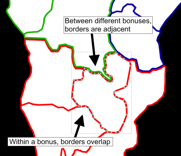
It is recommended that the borders of territories in the same bonus overlap, whereas the borders of territories in different bonuses should be adjacent. | It is recommended that the borders of territories in the same bonus overlap, whereas the borders of territories in different bonuses should be adjacent. | ||
| Line 7: | Line 7: | ||
For example, take a look at part of South Africa in Grundie's Earth map: | For example, take a look at part of South Africa in Grundie's Earth map: | ||
| − | + | https://d2wcw7vp66n8b3.cloudfront.net/Images/MapDesignBorders.png | |
| − | == | + | == Minimize long connections or drastically uneven territory size == |
| − | + | One property of a great map is that players can tell at a glance, without doing an analysis, approximately how many turns it takes to get from one territory to another. | |
| − | = | + | For example, on the [https://www.warlight.net/SinglePlayer?PreviewMap=12 Earth map], all territories are approximately the same size, and all connections between territories over water happen between territories that are relatively close to begin with. |
| − | + | Contrast that with this example, where territory labeled B is actually significantly closer to A than C is, even though it appears to be further away: | |
| − | ==See also== | + | https://d32kaghj56y4ei.cloudfront.net/static/img/LongConnections.png |
| + | |||
| + | Long connections like this make it harder to spatially visualize the map layout. A similar effect can happen when territories are drastically uneven in size. Just like before, B is much closer to A than C is, even though it appears further away: | ||
| + | |||
| + | https://d32kaghj56y4ei.cloudfront.net/static/img/UnevenTerritorySizes.png | ||
| + | |||
| + | This happens due to an extremely large territory being nearby to very small territories. | ||
| + | |||
| + | == See also == | ||
* [[Map Making]] | * [[Map Making]] | ||
* [[Creating the SVG]] | * [[Creating the SVG]] | ||
| + | * [[Map requirements]] | ||
[[Category:Map Making|Guidelines]] | [[Category:Map Making|Guidelines]] | ||
Latest revision as of 01:10, 19 December 2014
This section lists general guidelines that make exceptional maps. For a list of the requirements that a map must pass to be approved, see the map requirements.
[edit] Border overlap
It is recommended that the borders of territories in the same bonus overlap, whereas the borders of territories in different bonuses should be adjacent.
For example, take a look at part of South Africa in Grundie's Earth map:
[edit] Minimize long connections or drastically uneven territory size
One property of a great map is that players can tell at a glance, without doing an analysis, approximately how many turns it takes to get from one territory to another.
For example, on the Earth map, all territories are approximately the same size, and all connections between territories over water happen between territories that are relatively close to begin with.
Contrast that with this example, where territory labeled B is actually significantly closer to A than C is, even though it appears to be further away:

Long connections like this make it harder to spatially visualize the map layout. A similar effect can happen when territories are drastically uneven in size. Just like before, B is much closer to A than C is, even though it appears further away:

This happens due to an extremely large territory being nearby to very small territories.