<< Back to Map Development Forum   Search

Posts 1 - 5 of 5   
Arctic Map: 2/22/2012 13:57:38

Wolfspirit19
Level 2
Report
I'm new to *WarLight* (day 2) and I was thinking of creating an arctic map as my first design. I would include from about 65 degrees north to the pole, and then down to 65 degrees north on the other side, so this would include a lot of Russia, Alaska, Canada, and polar ice, which would still be capturable.

I would include a bonus for Russia, a bonus for Canada, a small bonus for holding the Pole, and maybe a hemispherical bonus on either side.

My other idea was a map of the entirety of Russia, with a little room to the east and south for more north-south room for playing. This would likely include Ukraine, Belarus, most of Eastern Europe, Turkey, Armenia, Georgia, and part of the Middle east.

I was just wondering which idea would make a better map, and also how to make a map at all (I looked at the wiki, I couldn't figure ti out). Thanks
Arctic Map: 2/22/2012 16:43:29

RvW 
Level 54
Report
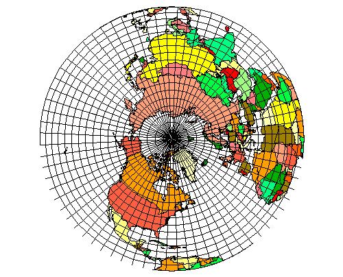
Both these ideas sound pretty ambitious. I'm not a mapmaker myself (yet ;) ), but what I gather from talking to people who are and reading the forum, it's surprisingly much work. So, maybe you should start with something simple, just to get the hang of it. Then when you have a little experience, you can make bigger, more complex maps.

I really like your idea for a polar map though. It's quite different from the maps already here and sounds very interesting!

Thanks to [Matma Rex](http://warlight.net/Profile.aspx?p=421306692), one of the mapmakers, part of the [process ([choosing centre points](http://warlight.net/Forum/Thread.aspx?ThreadID=2452) and [making connections](http://warlight.net/Forum/Thread.aspx?ThreadID=2668)) can be done mostly-automatically.
Arctic Map: 2/23/2012 19:35:49


ChrisCMU 
Level 61
Report
You'd probably have to use something like this as a basis for a polar map:

http://hosting.soonet.ca/eliris/gpsgis/LectureImages/azimuthalprojection.jpg
Arctic Map: 2/23/2012 19:50:00

duffer
Level 2
Report
If you're having trouble with understanding the whole map-making process, start with a really small map. You don't have to release it officially at all, just getting it done and having people who review it for you confirm it's got no bugs is enough. You'll know then you can manage the whole project of making a bigger map and will have some idea about how much time it's going to take.

So, think about a simple map of, say, ten territories at most. Even five is plenty, it's just for practice after all. Just get drawing and then upload it and go from there. Review the first steps in the Wiki and ask specific questions if can't understand something or are having other kinds of trouble.

That's what I am going to do anyway, when I have a bit of spare time. I have lots of ideas for potentially great maps, but I figure I want to just walk thru the whole process first with whatever little map I can quickly make the first time around. No reason to start something I might not finish when I am still inexperienced as a map-maker.

My idea for you: Just make each major country surrounding the North Polar region one territory. Place them approximately and draw them just well enough so they're recognizable. You can worry about making the map look good later when you're doing another one and intend to release it. Right now I think it's more important for you to get working. It'll take a bit to get used to the tools and options you have, but people here will help you!
Arctic Map: 2/24/2012 16:19:00

RvW 
Level 54
Report
@Chris:
That's a JPEG image, and not a very big one either. With a little searching I found [an alternative](http://www.esacademic.com/pictures/eswiki/78/Nansen%27s_Planned_Drift_map.svg) which is already in SVG format (and isn't littered with an enormous amount of latitude and longitude lines). That might be a better starting point.

Wolfspirit, please consider duffer's advice; I think he has a very good point.
Posts 1 - 5 of 5