| Geopolitical Earth Map: 2/14/2016 01:37:41 |

 Zephyrum
Level 60
Report
|
Oh yeah - Also, if possible, when it's coming together, if you want, I'd love to help testing it. Your maps are pretty enjoyable and now you're taking on a project that I've been waiting for a long time - a world map with single territory bonuses that is bigger and hopefully better than WN2012/WN2014.
|
| Geopolitical Earth Map: 2/14/2016 01:52:38 |

 Imperator
Level 53
Report
|
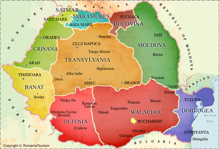
Thanks, I really do appreciate some love every now and then for making these things. They are a pretty big deal to make and it really hurts to hear that people hate your map, so thanks :) It's probably going to be at least 3 weeks until i get it completed enough to do testing, that is if I don't abandon it somewhere along the way. I really don't think that i will, since this is a project I really want to get done and that I think would really benefit the Diplomacy community. I pretty much am committed to doing it, even if I end up doing something like 2 territories a day for a year or something :P I am in contact with a guy privately about this project, and this is what he had to say about romania: 1. Romania is the biggie here. It looks very weird and could mess up a lot. If you want people to use this map for WWI games, or anything with the Austrian Empire (a LOT of history) then you NEED a Transylvania territory. I really suppose you divide Romania like this:
http://romaniatourism.com/romania-maps/romania-regions-map.jpg
Guidelines for merging territories:
Oltenia + Walachia = Wallachia
Moldova + Bucovina = Moldavia
Dobrogea = Dobrogea (small, but really important historically. Follows the river danube, and so many historical empires used it as a guideline: Byzantines, Romans, Persians, Cumans, Pechenegs, Ottomans, etc.) (If it is too small then merge it with Wallachia :P)
Banat + Crisana + Satmar + Maramures = Transylvania (officially called Greater Transylvania. This region is really pivotal for lots of empires, including Austria, Hungary, Austria-Hungary, Ottomans y'know :P) (it would be impossible to make Austria look good without this and this was a huge problem with World Nations 2014 It seems pretty similar to what you said to me, but I do need to read both more carefully. Does his seem alright with you? If so, I think i'll just use his solution.
Edited 2/14/2016 01:54:30
|
| Geopolitical Earth Map: 2/14/2016 02:26:19 |

AlternateHistoryGuy
Level 49
Report
|
I desperately want to test this. It looks awesome. Also, you may need to watch out for places such as Europe or America. Lots of large cities close to each other tends to unbalance games.
|
| Geopolitical Earth Map: 2/14/2016 02:26:51 |
Zephyrum
Level 60
Report
|
It's very similar. The one difference is that in my suggestion I pretty much put Dobrogea and Wallachia together, as he suggested if it ended up being too small. His opinion is EXTREMELY SIMILAR to mine. Anything with Austria gets wonky in WN2014 (and would get in your current Romania). It's also the reason I suggested those changes to Poland. Germany, pre-WW2, looks awfully wonky with that huge f*cking "Poznan" in WN2014 map. The biggie for me was not the existance of a Transylvania territory, what I really wanted to be not wonky was mostly Wallachia, and a less wonky transylvania would come by naturally with that. It helps a lot for Austro-Hungarian Empire (or just pre-habsburg Hungary in general). Take a look at this. Transylvania still under Austria, while the rest forms the nation of Romania. This, and pretty much every single combination that involves romanian land, will be very easy to make.  Having Dobrogea would open some more possibilities, but just having the three major parts of romania under that arrangement is GREAT and helps a lot. Dobrogea is asking a little bit too much due to it's awfully small size, so unless you're playing with someone that is one big nitpicker, it's great as-is.
|
| Geopolitical Earth Map: 2/14/2016 02:31:04 |
Imperator
Level 53
Report
|
Alright, thanks for saving me some brain-work with that :)
I just put together a Guide for a GDP-based map, and I'm going to test it our right now. Let me know what you guys think:
1 Billion< - 1
1-10 billion - 2
10-20 billion - 3
20-50 billion - 4
50-100 Billion - 5
100-250 billion - 6
250-500 billion - 7
500-1000 billion - 8
1 Trillion> - 9
Edited 2/14/2016 02:31:35
|
| Geopolitical Earth Map: 2/14/2016 02:39:19 |
Zephyrum
Level 60
Report
|
Sounds great! Can't wait to see California break the game :P
|
| Geopolitical Earth Map: 2/14/2016 02:40:40 |

Cata Cauda
Level 59
Report
|
Zeph, is just nitpicking about teritory borders, because he can include pictures.
|
| Geopolitical Earth Map: 2/14/2016 02:46:43 |
Imperator
Level 53
Report
|
It depends on what you mean by "Steal" lol.
If you want to use what I've done so far I don't have any problem with it in principle, although you will have to trace it yourself; Don't expect to get the SVG out of me :D
If you want to make your own map starting from the same SVG world map I did, you can go on wikimedia commons and find it yourself :)
|
| Geopolitical Earth Map: 2/14/2016 03:33:35 |
Imperator
Level 53
Report
|
Alright, so I'm having a lot of trouble finding GDP info for Norway, and I don't even want to imagine finding it for obscure third-world countries.
If anyone has ideas for good sources for this info, be sure to let me know and Maybe i'll try to work on this some more.
|
| Geopolitical Earth Map: 2/14/2016 04:06:27 |
Zephyrum
Level 60
Report
|
I'm not sure how much you trust Wikipedia, but it took me literally 40 seconds to find complete information on Norway. https://en.wikipedia.org/wiki/List_of_European_regions_by_GDPIf anything, Wikipedia is... acceptable, if you ask me. :P Edit: I just opened the map and saw the changed I suggested in Poland! :D It looks so much better now!
Edited 2/14/2016 04:09:36
|
| Geopolitical Earth Map: 2/14/2016 04:12:31 |
Imperator
Level 53
Report
|
I found that, but Its use is really kind of limited since I used counties of norway rather than regions for the territories on my map. I suppose I may be able to kind of get a rough idea from it, but it's not something I'm really looking forward to.
|
| Geopolitical Earth Map: 2/14/2016 04:20:23 |
Imperator
Level 53
Report
|
By the way, here's the new version I'm workign on with GDP: https://www.warlight.net/Play?PreviewMap=53200
|
| Geopolitical Earth Map: 2/14/2016 07:10:29 |

 DesertFox
Level 57
Report
|
About Naminig territories, name Constanta -> Bucharest , and Bucharest->Cluj Napoca (cause the position of Bucharest territory is a bit odd .
|
| Geopolitical Earth Map: 2/14/2016 07:48:25 |

 xXOmegaXx
Level 55
Report
|
Is this a continuation of your previous attempt of Belgian Gentleman's SVG?
The only way I could think of balancing China and India is to cap the income per territory at 15, although you still might have to mix in GDP and military.
|
| Geopolitical Earth Map: 2/14/2016 13:14:47 |
Imperator
Level 53
Report
|
No, I'm redrawing mine completely from scratch. I was partially inspired from Belgian Gentlemans map, but other than that it's a completely original work as far as me drawing the SVG.
I'm currently working on doing it based only on GDP rather than population using a 9-tiered system of bonus values. I posted the link above so you can take a look, but I have only done the UK, Ireland, Belgium, and the netherlands so far.
Desertfox, I'm planning to completely redo romania, so let me know what you think after I do that tonight :)
|
| Geopolitical Earth Map: 2/14/2016 14:37:33 |

DW: Soz, NGL, I Play SLOW. UV BN Warned! 
Level 57
Report
|
Omega said:
The only way I could think of balancing China and India is to cap the income per territory at 15, although you still might have to mix in GDP and military.
There are several other options:
1) You can decline to create a single national bonus for China OR India... not ideal.
2) You can still take into account land area, uninhabited land, sea access, coastal zones, etc.
3) You can create bonuses for other militaries: Nato / EU, the African Union, as examples, that don't represent true nations, but would form a counterweight to the bigger military nations...
4) You can use real world / artificial barriers for nations with huge bonuses:
the Artic Ocean limits Russia and Canada in the real world, as do the Himalayan Mountains for China, India, and others.
5) You could ignore the real world treaty saying that Antarctica will only be used for small scale scientific research, and instead give portions of it to each of the Southern Continents.
As for the map bonuses in general:
You could base the bonuses off of military, or GDP, or population, or military resources, or the amount of milk chocolate that they produce in a year...
but the thing about war in the real world is that it exposes the weaknesses and the strengths of the nations involved, as well as the accuracy of those measurements,
both for the nation in question as well as it's adversaries...
I doubt that can north korea feed it's people long enough to conquer much beyond south korea...
can india and china feed their people through a war without the risks of a significant drought? let alone with their immediate neighbor of comparable muscle?
Personally, I think that bonuses should focus on playability...
Perhaps extra distribution modes could help somehow? :)
Edited 2/14/2016 14:38:24
|
| Geopolitical Earth Map: 2/14/2016 14:40:15 |

 Жұқтыру
Level 56
Report
|
I suggest you do the bonus names as the English exonym, and the territory name as the autonym.
|
| Geopolitical Earth Map: 2/14/2016 14:40:26 |

Riveath
Level 59
Report
|
Poland still looks terrible, especially the middle territory. At least make the shapes a bit more regular, really. No need for administrative correctness, just make them look aesthetically, please.
|
| Geopolitical Earth Map: 2/14/2016 14:48:59 |
Жұқтыру
Level 56
Report
|
Poland looks fine to me.
|
| Geopolitical Earth Map: 2/14/2016 14:49:50 |
Imperator
Level 53
Report
|
I suggest you do the bonus names as the English exonym, and the territory name as the autonym. Pretty sure the word you're looking for is Endonym, not autonym... I can probably do this, but It may be a bit troublesome for places that don't use Latin-based alphabets. I'd have to look into it more later, but that's the first thought that comes to mind. Poland still looks terrible, especially the middle territory. At least make the shapes a bit more regular, really. No need for administrative correctness, just make them look aesthetically, please. The reason I pretty much need to use administrative divisions is to be able to collect statistics and use them as Bonus values. It's pretty hard to find the GDP of "This random spot I drew in the center of Poland".
Edited 2/14/2016 14:50:21
|
Post a reply to this thread
Before posting, please proofread to ensure your post uses proper grammar and is free of spelling mistakes or typos.
|
|